Tuesday, January 5, 2016

Greenbrier Pinnacle

Off-trail in The Great Smoky Mountains

Hike off-trail at your own risk!


View from thr Cat Stairs
I met Mike and new hiking friend Joe Ferrell in Greenbrier around 8am and the adventure soon began. We start off walking along the old roadbed headed towards Ramseys Cascades. Its a nice walk that gives Joe and I time to get acquainted while Mike schools us on our surroundings. After about a mile and a half the roadbed ends at a turn around where the trail to Ramseys continues and a unmarked trail switches back off to the left.

Mike standing at the Greenbrier Pinnacle Trailhead
That unmarked trail is where we're headed. The trail begins as a well-defined path. Although its a steady uphill walk, its not particularly steep. As we continue, there are many downed trees (some very large) that we have to either climb over, go around or even crawl under. Although this is an old jeep road, its hard to imagine that today as time has eroded much and the forest reclaimed most of it. There's a few spots that become ugly and difficult with several slaps to the face by encroaching vegetation of all sorts. Joe was particularly fond of the brier patches!

Joe fought the briers and the briers won!
As I remember, and since my GPS was malfunctioning (!), it was about a mile and half from the junction when we came to a few extremely large trees. One directly to the right touching the trail and another a few tenths of a mile further up, also to the right of the trail about 10 or 20 feet. There are many rhododendron tunnels along the way, and you know how much I love rhodo-tunnels!

Mike and the beanstalk... uh, I mean big tree!
At 3.1 miles from Ramsey Prong Roadbed, we made it to the overlook to the left. Absolutely amazing!

View from the Pinnacle Overlook
After a much need lunch break and some good conversation, we take bunches of pictures and decide to head on up to the top where the old fire tower used to be. At this point we're just kinda playing it by ear as to what the ultimate destination might be due to the fact that we're all old and the weather could take a turn. But the weather is fine as we head up the next .4 of mile. The trail to the top is directly behind you as you look out at the overlook and is also mostly well defined, however it is a steep climb and quite difficult to maneuver as it is seriously overgrown. More face smacking and brier snagging!

This steel post marks the end of the steep climb up to the ruins of the cabin and fire tower.
At the top, we find where the old cabin once stood directly in front of the fire tower ruins. Mike posted a great video about it. Notice the Hollywood style camera work?

The cabin well
Fire tower ruins
From here, we return the way we came and Mike stops at a faint side trail that leads the way to the Cat Stairs. The three of us decide we're ready for more, so Cat Stairs, here we come!

Cat Stairs Trail
The "trail" is very faint to nonexistent almost immediately. This is for all intents and purposes bushwhacking. A few very steep drops, some crawling and climbing and a few glimpses of beauty above the forest growth are keeping us alert.

Cat Stairs Trail. Trail? We don't need no sticking trail!
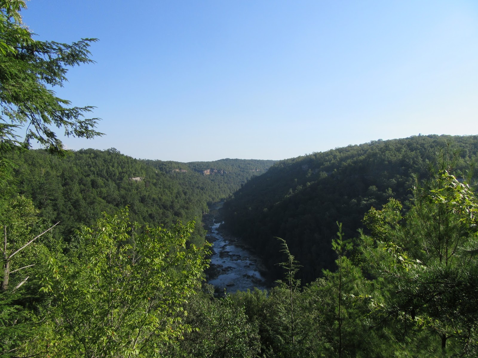
Upon reaching the "stairs", the word steep takes on an entirely new definition. Mike suggest we scoot down the dirt on our butts and leads the way. I try to maintain on foot with success, albeit frightening success, while Joe goes full on dirt slide behind me. Joe took a few unplanned scoots here and there and earned himself a new trail name: Scooter. We came to a protruding rock after, I may be wrong here but I think it was after this first major downhill slide, where the view rivals any that I've seen in the park. Stunningly amazing.

View from the Cat Stairs
Another view from the Cat Stairs
Soon we're to the next couple of super, incredibly steep drop-offs. More amazing views along the way.

Scooter earning his trail name!
Mike goes scooting down, down, down!
Cat Stairs
Views!
Amazing views!
After we finally made it safely through the Cat Stairs we start doing some sideways walking through the super steep forest.

The Greenbrier Pinnacle. We just came down the left side!
The trail disappears a time or two so Mike just wanders here and there until it reappears like magic. I made it all the way through the Cat Stairs and all the ridiculous steepness only to trip over God knows what and take a little fall to my knees as we made our way to a well worn trail. This trail leads to familiar territory. A nice walk leads to the Barnes place where Randy and I walked with Mike about a month ago (link: Mike Hike #4).

Barnes Place
Barnes Children Graves
From here we hike on out with one little Mike Maples shortcut along the way. A nice area just over a long rock wall that he referred to as an old CCC dump site. A cool way to end one of my most favorite days in the park. 

Old CCC truck
Forgotten bridge supports
As much as love the trails in the Smokies, there's something magical about going where few will ever tread. Having the extraordinary opportunity to join Mike for these adventures is a blessing. So, in summary, the weather turned out perfect and no one got (seriously) hurt and the hike was absolutely amazing. Easily, one of the best ever! I call that a great day!

Thanks, Mike!

Sunday, August 2, 2015

Angel Falls Overlook Trail

Big South Fork National River and Recreation Area
Oneida, TN

Last hiked April 24, 2010

The Angle Falls overlook is located in the Leatherwood Ford area of Big South Fork and is one of the most popular hikes in the Big South Fork. It was also the first trail I ever hiked solo and as such, it holds a special place in my hiker's heart.

After parking at Leatherwood Ford, to access the trail, there's a bridge crossing the Big South Fork section of the Cumberland River. This bridge is very wide and also low near the water which means it is often washed out. If the bridge is washed out, crossing the water is not a safe option here. Fortunately, there is another alternative. You can walk back to the road and cross over the car bridge and there's a visible trail that leads down the bank and to the trailhead.

The bridge leading to the Angel Falls Overlook Trailhead in 2010, all washed out.
The trail begins as a wide flat walk through the woods along the river. Soon there are large walls of sandstone that tower overhead. At around 2 miles, you reach Fall Branch and cross over a rather large footbridge. On one of my many visits here, this bridge had been caved in by a huge fallen tree which made for an interesting and somewhat scary crossing across broken boards and chunks of tree.

Soon, past this bridge, the trail comes to a very sharp and easy to miss switchback. My first solo hike here was made much more difficult when I missed this and followed what looked like a well worn trail until it simply disappeared into blank forest. I spent a few miles wandering off trail before finding my way back. A good, fun adventure but not a smart thing to do for a novice like me at the time. Actually, not very smart even for a more experienced hiked.

Off trail after missing the switchback.
After the switchback the hike becomes more moderate as it climbs to the overlook. After passing a rockhouse to the right, another easy to miss right turn leads up several steps with a cable to assist the ascent. From here, you soon reach the junction with the Grand Gap Loop Trail and take a right turn towards the lookout. The lookout is spectacular.

View from atop the Angel Falls Overlook
There's also a loop hike at the top, The Grand Loop, that can add around 7 miles to the overall hike but I've yet to conquer it. I did, however, have a very up close eagle sighting here. I've lost count of how many times I've hiked here but it's been a long time... I need to get back soon.


Max Patch

Pisgah National Forest
Harmon Den, NC

May 30, 2014

Max Patch is an almost completely cleared 4,600 foot tall mountain top that is a easily accessible via a short 1.4 mile loop across its summit. It offers panoramic views of the Smoky Mountains and beyond and a chance for almost anyone to walk along a small portion of the Appalachian Trail that runs along the summit.

One of many views from atop Max Patch
My friend Eddie and I decided to drop by Max Patch after hiking the Hemphill Bald Loop Trail earlier the same day. After already hiking almost 15 miles, I was pretty whooped by the time we got here. We immediately chose to hike the big loop that climbs and circles the bald in about 2 and a half miles instead of the easier and shorter loop. We're stupid like that. The hike up is kinda steady but its hard to judge it properly since I was so tired already. Regardless, after reaching the top, it was beyond worth it! Its incredible.


The gravel road leading to Max Patch is rough but the hike is very short and easy enough for most. The views are spectacular!


Grayson Highlands

Grayson Highlands State Park (Jefferson National Forrest)
Mouth of Wilson, VA

May 16, 2015

While continuing our annual tradition of attending Trail Days in Damascus, VA., Eddie and I along with Randy decided this year to add a little hiking to the mix. So, after hanging out at Trail Days all day on Friday, we stayed the night and spent Saturday hiking the Grayson Highlands.

The Grayson Highlands are known for the wild ponies, spectacular views and as being part of the Appalachian Trail.


Soon after beginning our hike, we came across our first encounter with the not-so-wild ponies. Its really an amazing sight.


The trail itself is rather adventurous with many, many large rocks to climb and terrific views at every turn. At every lookout, we though it couldn't get any better... until the next lookout.


If there's anything negative about this hike, it would be the complete openness of it all. There is no hiding from the elements here. It feels like walking the plains of the wild west, at times, even though some peaks reach over 5,000 feet.

All told, we walked around 8 miles and I'm pretty sure we'll be back next year. Highly recommended!

Honey Creek Loop Trail

Big South Fork National River and Recreation Area
Oneida, TN

August 1, 2015


The Honey Creek Loop trail is no ordinary hike. Although its under six miles in length, it likely will take just as long as most hikes almost twice as long. That's because there are many steep areas, creek crossings and rock climbing along the way.

View from the Honey Creek Overlook
After a long and somewhat adventurous drive on some deep country and rough gravel roads, I met up with Randy at the trailhead. We met Jack Sexton, a local, while getting our gear together and he was hoping to hook up with a hiking partner, so he joined us for the hike.


There are many wonderful things about Honey Creek. Although its a very technical trail, the amazing rock house and waterfalls more than make it worth while. The trail is marked but can be a little confusing at times.


The waters were low on our visit, so the waterfalls weren't flowing much but we also had it easy on some of the usually wetter areas.


This is a remarkable and beautiful hike. There's a bit of climbing and crawling (and a lot of wading in higher waters) so it may not be for everybody but its a nice departure from the ordinary trail. I'll definitely be back!

Virgin Falls

Vigin Falls State Natural Area
Sparta, TN

October 12, 2013


View from Maths's Pretty Point Overlook

Virgin Falls

Virgin Falls

Tranquillity